
The following is a Community Cycles memo to City staff for a meeting held with the Planning and Development Services department who are managing the transportation portion of the CU conference center development.
CU is a state entity so this development does not go through standard Planning and Development review processes and just has to meet the Design and Construction Standards (not our TMP or VZ goals or public review processes). Any special processes that the development would have to go through could be legally challenged. This is very frustrating for an unsafe design.
Here is the summary of the meeting held on October 19th:
- The city is considering our request for a traffic study update to include bicycle volume and the existence of a MultiUse Path.
- The city heard our request for a safety study. Per code, the Director can decide if a crash analysis study needs to be part of the traffic study. Predictive crash analysis in Boulder is not usually done… The safety study should look at volumes, types and desstinations of pathway users, speed of those users, number of potential conflicts, sight line issues, and counter flow travel issues.
- The sight lines and turn lane lengths don’t meet code, however these are the existing conditions on Broadway/CO93 and CDOT allows this, even with large increases in the volume of traffic. The city can’t force CU/Limelight to meet this code.
- The city will look into the Trip Distribution in the traffic study, including a bad assumption that there will be no additional Southbound lefts at University.
- The city will look into widening University to allow for additional queuing of vehicles if the dangerous southbound left off of Broadway is closed. The city has concerns about vehicles weaving and there are major cost impacts. CDOT would have to review removing the southbound turn from Broadway.
- The city said the NARF re-route proposal has to be on the table for planning purposes due to future impacts.
Here is the memo to Staff:
Questions regarding Traffic Study:
Bicyclists, pedestrians, and the MUP are not mentioned. Doesn’t the DCS require MUP analysis in the traffic study?
Questions regarding standards
Entering Site Distance: From the entering (Grandview) vehicle to the highway (Broadway) vehicle.
The State Highway Access Code requires there be minimum sight distances for exiting vehicles and on-coming traffic (Section 4.3 (3) Entering Sight Distance) This distance is calculated using inputs of posted speed, number of lanes, expected truck types/volumes, and grade. If we assume for a moment that only a single multi-unit truck will be exiting at Grandview headed north on Broadway a day, this minimum distance is 607 feet. Captures from the State Highway Access Code are below.
Similar to above, must be multiplied to adjust for downgrade. Per table 4-4, “5%-7% Downgrade, Use 1.35”
Assume for now less than 2 multi-unit trucks per day. Site distance needed is 450*1.35 = 607 feet
We went out and measured the sight distance of an exiting vehicle at Grandview looking to the south. Per the State Access Code this was measured at 10 feet back from the edge of Broadway at a height of 3.5 feet. 607ft was not visible because it was after the crest of the hill. If you are onsite, you will see a railing along the sidewalk on the south side of University. There is a dent in the railing. That is about the 607 ft mark.
CONCLUSION:Due to the crest of the hill, this minimum sight distance is not met, thus no vehicle traffic should make this movement. To prevent this movement from happening it should be redesigned and constructed such that it is physically impossible for any vehicle to make this movement.
Assumption Questions:
Trip Generation
The traffic study assumes a 20% modal split reduction for the hotel and retail space, meaning that 80% of people would arrive by driving alone, as well as during any trips they make during their stay. The city has the goal of achieving a rate of driving alone of only 20% for residents and 60% for non-residents by 2030, well before the 2042 planning horizon of the hotel traffic study. As of 2018, residents drove alone on 37% of trips, and non-residents drove on 78% of trips. (Source: 2020 TMP report on progress) There is a 40% modal split reduction for the restaurant, which will generate considerably fewer trips than the hotel.
All trips generated by hotel guests are assumed to depart the site. However, the site has a planned mix of uses, including dining and retail. Some amount of guest trips will remain on the site, not generating any vehicle traffic. However, the traffic study does not identify any internal trip reduction.
Can the city request that the traffic study comply with the DCS requirements for data-backed modal split and internal capture?
Trip Distribution
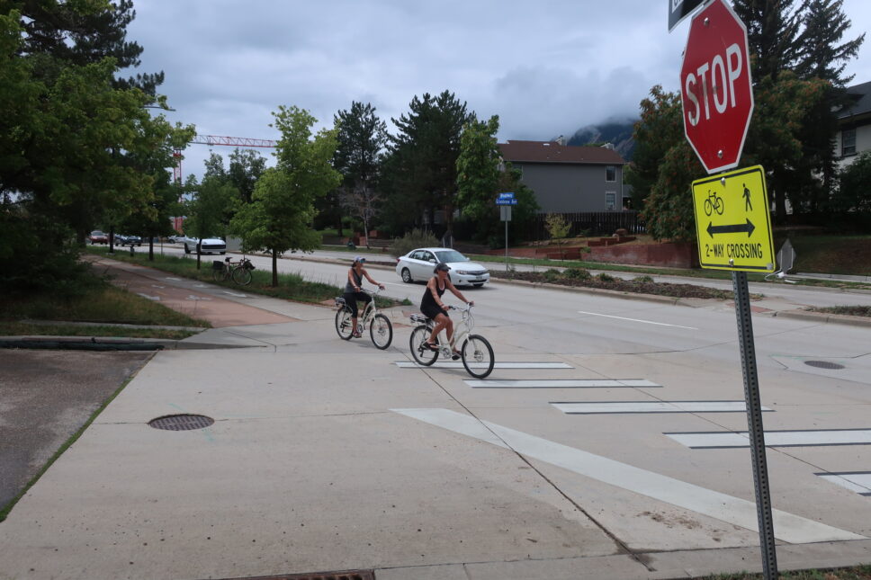
During the busiest hour of the day, in the PM peak hour, it is anticipated that the development will generate 103 trips into the site. With the modal split reduction factor applied, the total vehicle trips into the site would be 78 (Table 2). The distribution of trips, summarized in Figure 6, shows that only 15% of people will arrive at the site from the north, using Broadway to pass through the Arapahoe intersection and then turning left onto Grandview. With these inputs, it is anticipated that 12 vehicles an hour will access the site via a southbound left turn from Broadway to Grandview (78 vehicle trips X 15% = 11.7 vehicles). Each of the 12 drivers making the turn across the multi-use path poses a threat to people walking and bicycling across this unprotected crossing. However, the impact of one additional vehicle every five minutes using the signalized intersection of University at Broadway and the 13th Street intersections is almost negligible in the context of all of the other anticipated traffic.
Would the City be concerned about an extra 12 cars on University in the PM Peak Hour?
95th Percentile Queue Lengths
The updated traffic study indicates that by closing the dangerous southbound vehicle left turn from Broadway to Grandview, additional vehicles would then likely use a left turn from University to 13th Street to access, and they could back up, blocking the intersection of University and Broadway. The traffic study states the reason for a backup would be westbound traffic queueing at the Broadway signal can back up all the way to 13th Street, blocking eastbound drivers trying to turn left onto 13th Street. It shows that after 20 years of increased traffic, during the 2042 PM peak hour, in a bad-case scenario (95th percentile), the traffic queue will block 13th Street by about one car. Queue lengths are depicted in Figure 10 of the study. The study did not identify any mitigation strategies to keep the intersection clear, such as “don’t block the box” or other pavement markings and signage.
Does the city think the projected queueing for westbound University is reason to not close the southbound left on to Grandview?
Alternatives:
1- University widening for an additional turn lane
SB left turn lane
The TIA states that the SB left turn on Broadway at Grandview should not be closed because there is “… no left turn storage area on University Avenue in which to queue vehicles [attempting to turn left at 13th]. Backups in this location have the potential to block the signalized intersection at Broadway/University Avenue.”
This appears to be solvable by adding an EB left turn lane on University at 13th. Queuing would still occur, but it would not block EB through traffic. The existing SB left turn on Broadway was deemed to be sufficient length and has 80 feet of left turning vehicle storage.
Looking at the parcel data shows that the public ROW of University is just as wide as Broadway — 100 feet. In fact, Broadway has 5 vehicle lanes (not including the proposed 6th decel RT lane) while University only has 4. There is space for another lane on University.
Adequate Length of a new EB LT lane
They are showing 15 SB lefts onto Grandview in the AM and 18 in the PM. So prohibiting that movement (with a raised median) would shift those trips to a new EB LT lane on University to get into the site. The existing SB LT stacking length on Broadway was determined to be sufficient to accept all of these new SB lefts and is approximately 80′ long (typically the taper is not included). The rough diagram shows that a new EB LT lane on University could be added that is approximately 170′ in length. Even if you added the taper area on the SB LT on Broadway (which in some locations in the City is needed for cars to dwell out of the through lanes) it’s only about 120′ in length.
EB Through Traffic on University
Adding a new left turn lane on University would force the EB through traffic to shift 10′ farther to the south than what is done today as shown on the attached (We have assumed a 10′ LT lane width). There are maximum geometric thresholds for making those shifts, set in place to make sure drivers can stay in their lanes. As best as we can tell from the aerials, it looks like the shift would be 13 feet. Given 25 mph posted speed, the MUTCD recommends 135′ to make this shift, however it looks like there is only about 120′. That said, it could be reasonable to allow a design exception here because 1) The new left turn lane is a newly generated lane traveling in the same direction; 2) the SB LT and EB through movements would be in different phases (ie not competing) and 3) it seems unlikely that EB left turning vehicles will queue all the way back to the intersection. Additionally, there could be widening on the north west side of University to better pair up with the east side changes. 
2 – Crossing Grandview at 13th street alley
In this alternative, the bike path would cross the corner of the conference center site and cross Grandview at the NARF alley (with a raised crosswalk, an overhead HAWK or an underpass) then proceed down the alley to meet back with the Broadway MUP just south of the Arboretum. This would require some re-grading or switchbacks to deal with the grade change, but the grade change is less than slightly east on the site.

3 – CU’s proposal around 13th in front of the Conference Center
CU has proposed moving bike traffic off of Broadway at University, going in front of the hotel with sharrows crossing Grandview and then building a fly-over. We feel this is too far of a detour, has too much mixing with traffic on University, traffic making a left onto 13th and drop-off and pick-up traffic in front of the hotel. The fly-over is very expensive, would probably require valuable city funds, and would take years to be built. We strongly do not support this proposal.
General questions
Can the city ask for another traffic study that looks at bike/peds and the MUP and answers our questions above regarding sight distance, queuing and traffic projections?
Can the city and CDOT close the left off of Broadway? Would the city be open to this? If not, why?
Can the city /CU amend the MOA?
We don’t see anything in the MOA that states that the City is required to provide access to its street network via Grandview and Broadway. This is the section: “Access to Public Streets. The University shall be given access to city streets and roadways at such points as are reasonably necessary to develop the CCH project and consistent with applicable provisions of the state highway access code and Boulder’s site access standards.” We don’t see anything in the MOA that relinquishes the City’s ability to restrict access from that intersection.
Why doesn’t the City close the east access of the Grandview/Broadway intersection altogether? Some of the benefits: 1) The cost to doing so would be equivalent (or less) than adding a NB deceleration lane. 2) The city ROW between Broadway and the first driveway could be vacated by the city and given to CU. This would allow CU more space to build. 3) It removes a non-conforming access, as defined by the City’s own standards. 4) Removes an uncontrolled left turn across Broadway (the SB left turn onto Grandview). This could allow the City to replace the left turn lane with a planted median, connecting the medians to the north and the south. Note that between Pearl and Baseline there is only one other uncontrolled intersection with left turns (Marine). Connecting the medians could increase winter driving safety as NB vehicles would be blocked from sliding into the opposing SB lanes. 5) It greatly enhances safety of existing and future cyclists and pedestrians on one of the City’s most heavily used paths.
What is the timeframe for signing off on the plans & ROW Permit?
Can you explain the applicability of BRC ‘9-9-5. – Site Access Control’ for this site?